Below are some of the images I included in my site identity. The colored site analysis shows the location of the building programs as well as their relevance to the river, nearby bridges, and two cities.


Below are some renderings I created to give a better sense of the bridge.


TOP PLAN ABOVE

BOTTOM PLAN ABOVE

EAST SECTION VIEW

WEST SECTION VIEW (actual landscape in background)
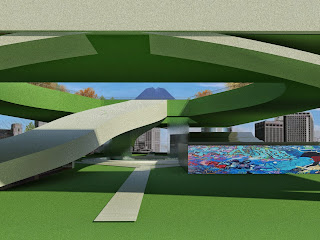
View down the pathway from one side of bridge on first level. Here you can see the graffiti wall, the ramp that leads through a large overlook opening, and the waterfall in the center, as well as the scenery of the city in the distance.
No comments:
Post a Comment